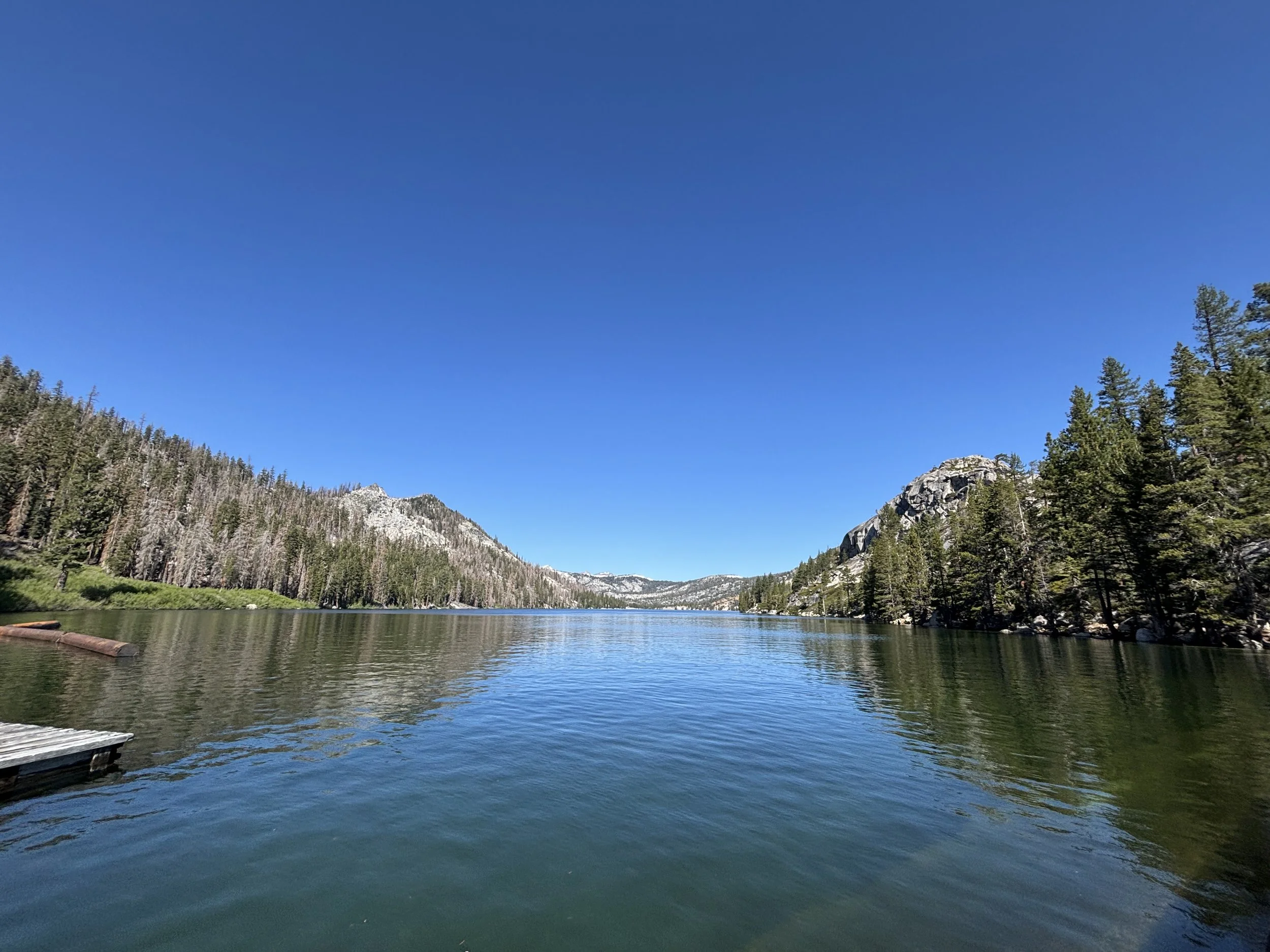
Tahoe Rim Trail
Aug 23 - Sept 3, 2026
The countdown is on... and this is the one we've been dreaming about! From August 23 to September 4, we're taking on the legendary Tahoe Rim Trail—170 incredible miles of alpine lakes, granite peaks, towering pines, endless views, and memories we'll carry forever. There will be early mornings, sore legs, unexpected challenges, and moments where we'll question why we signed up... but that's exactly where the magic happens. Every step is a reminder that we're capable of more than we think. So here's to embracing the unknown, trusting the journey, and proving to ourselves once again: I CAN do this... and now I WANT to do this! Let’s GOOO!!
Here’s our trip itinerary in a different format with more detail and the ability to update a little easier. Plus, you can share this with family as well.
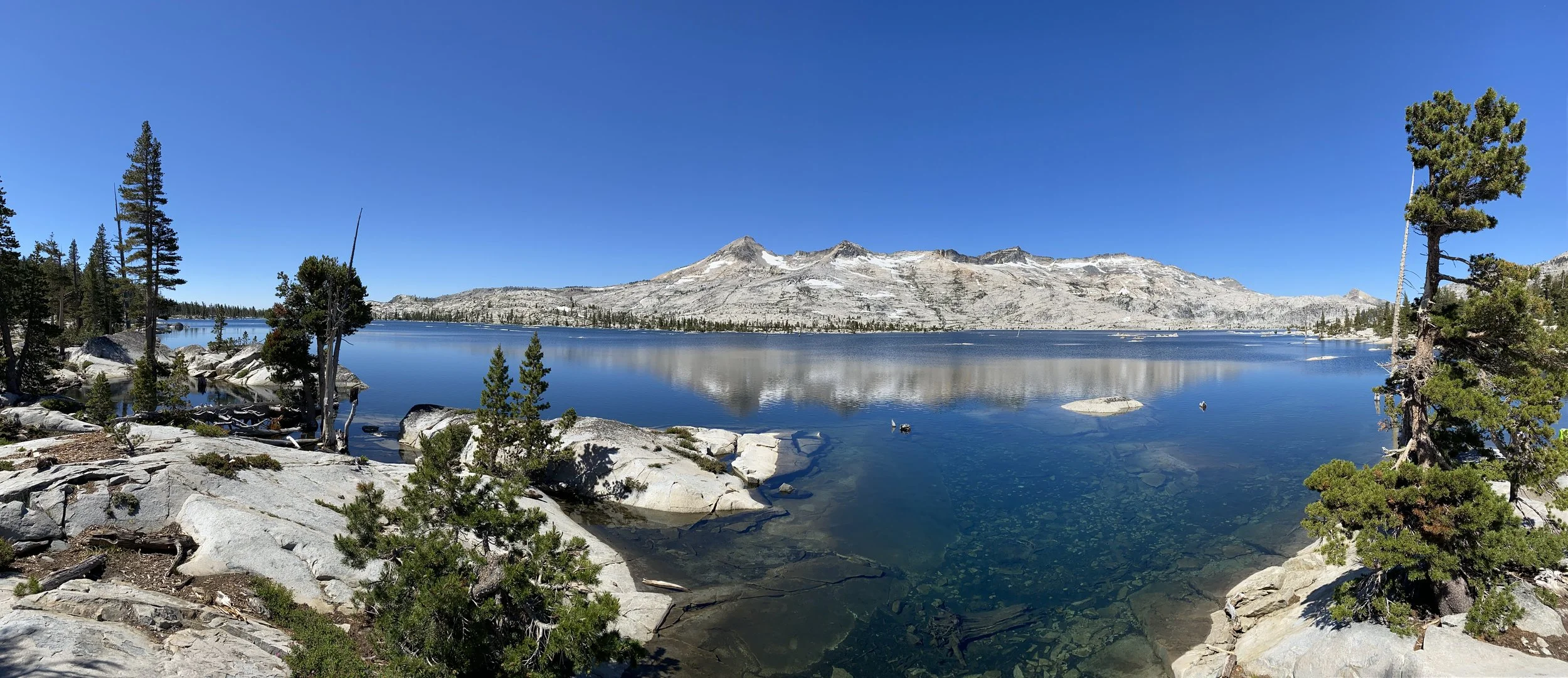
Trip Itinerary & Overview
August 23 - Arrival in Tahoe
Carpool to Tahoe. I can drive up. Shores is welcome to stay at my house Sat night (if needed), we’ll pick up Black and Hess on the way.
Arrange support packages to Tiff for south end (Spooner and Luther Pass).
Confirm passes & permits.
Check in to hotel Bally’s Aug 23, C# H-05KPDRKT952FF 2 Deluxe Rooms, Check-in 8/23 4PM, Check Out 8/24 11AM
Arrive in Tahoe fairly early. Sort out details, pick up any last minute items, pack, maybe a short hike, clean out truck…etc.
August 24, Day 1 - Echo Summit to Dicks Lake
14.8 Miles, 2800’ gain
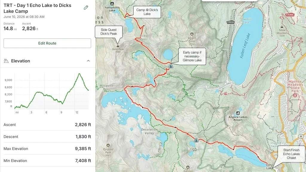
Day 1! Check out of the hotel about 7am. Grab a good breakfast and maybe a grab n go lunch, enroute to the trailhead at Echo Lakes Chalet. We’re not in a huge hurry because the water taxi doesn’t start until 9am. Park and get on the water taxi at the Echo lakes dock at about 8am (fingers crossed it’s still running.). The water taxi costs $25/person, one way, 4 person minimum. This will also take about 2.5 miles (about 1 hour) off our first day. It’s a beautiful ride and well worth the trip. Exit the water taxi at Upper Echo Lake and start hiking towards Dick’s lake.
Starting elevation at Echo Lakes is 7,400’ and will rise to 9,400’ at the top of Dick’s Pass, about 10.5 miles into the hike. There’s plenty of water along this section of the trail. We’ll walk near Echo Lakes, Lake Aloha, Heather Lake, Susie lake and Gilmore Lake before we start our climb up Dick’s Pass.
Our first climb is just off the dock at Upper Echo Lake, starting at about 7500’ and climbing to 8400’ over about 2.5 miles. It’s not a tough climb. This section of the trail is also part of the PCT. It’s well travelled, rocky and somewhat exposed. We reach the summit at Haypress Meadow where the trail conditions improve as we descend to Lake Aloha and a few other lakes along the trail. Just past Susie Lake we will begin our climb up Dick’s Pass. This climb starts at about 7,700’ and rises to the top of Dick’s pass at about 9,400’ over 3.5 miles. There is a side quest to Dicks Peak. A 1.4 mile out and back trail ascending about 700’ to the top of Dick’s Peak. If we complete that we begin our descent into Dick’s Lake for the night. A 1.7 mile 900’ descent with 18 switchbacks to the saddle above Dick’s Lake. Campsites are near. There’s plenty of Dick’s (Lake) water at the campsite.
Day 1 is about 12.3 miles of hiking (still praying the water taxi is running), not including Dick’s Peak, a good distance for Day 1. We can cut it short, if needed, and stay at Gilmore Lake, below Dick’s Pass but we’ll have to make up the difference in subsequent days to stay on track.
August 25, Day 2 - Dicks Lake to Barker Pass
16.5 Miles, 1600’ gain
Sunrise/Sunset 6:22am - 7:40 pm Temp 80/47
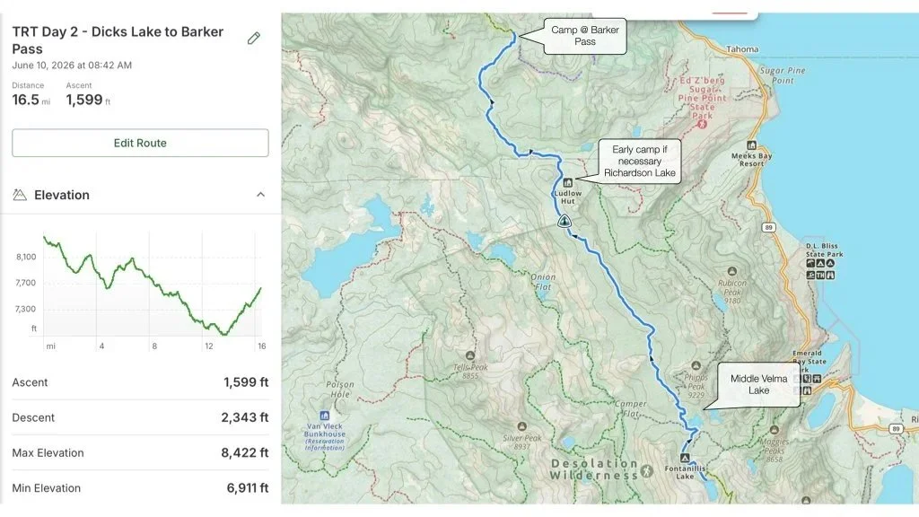
Day 2 starts at Dick’s Lake with our target destination being Barker Pass Rd. area, about 16.5 miles and 1600’ of gain, however from start to finish we will descend about 1000’, from 8400’ at the start to about 7300’ at Barker Pass. To start, we leave Dick’s lake and quickly travel past Fontanellis Lake, one of the more beautiful Lakes on the TRT/PCT that I’ve seen on past hikes. The trail changes from rocks to more of a forested area. A few miles later we descent to Middle Velma Lake area, the last good lake and water source along this section for several miles. This is a good place to filter water as the next reliable water source is 8.3 miles away at Richardson Lake.
Nearly 8.5 miles into our hike we meet the Desolation Wilderness North Boundary. In about another mile of rolling descent we will cross the north shore of Richardson lake, a popular lake for TRT/PCT hikers and OHV users. A dirt road arrives to Richardson Lake from Tahoe’s west shore. It’s the only lake on this stretch of the TRT for several miles, a good water source with about 6.7 miles to the Barker Pass Trailhead. We continue our descent for about another 3 miles and then begin a modest climb through meadows and a few more streams that may provide enough water to filter. Eventually the trail ends at Barker Pass. Cross the dirt road and we’ll find a place to camp out. The Barker Pass to Tahoe City Trail starts here.
Pretty straightforward section of trail.
Water at Dick’s Lake, Middle Velma and Richardson lake.
August 26, Day 3 - Barker Pass to Tahoe City
16.1 Miles, 1750’ gain
Sunrise/Sunset 6:23am - 7:39 pm Temp 78/45
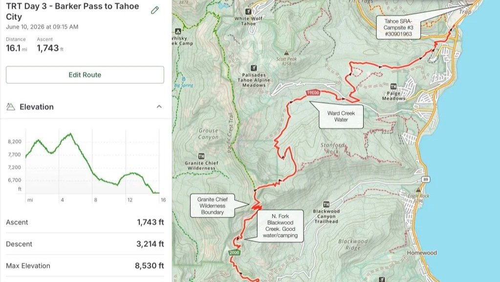
Day 3 starts along Barker Pass and finishes at our campsite in Tahoe City, about 16 miles and 1750’ of gain. We’ll start with the water we had from the day before. An initial climb up to the Sierra Crest gives way to views of Lake Tahoe. Shortly after that we cross a stream that could be a source to filter water from but it’s also an unreliable water source. We continue cross a steep face with more views and begin to descend into a bowl. Near the bottom of the bowl, about 2.5 miles from the trailhead we’ll come across several nice camping sites. We may choose to stay here instead of near Barker Pass as an option. Here there is a running stream, the North Fork of Blackwood Creek, a better more reliable water source. The trail continues a few more miles before ascending into the Granite Chief Wilderness.
About 5 miles from Barker Pass, the TRT /PCT split from each other, we stay right. and continue our descent into Ward Canyon. Keep an eye out for the 30’ McCloud Falls, just off the trail on the left. Switchback down for about another mile towards Ward Creek. We’ll come across a wide bridge over Ward Creek, a good place to soak out feet and grab more water. Just past the bridge is another campsite. Eventually we will cross Ward Creek Blvd. where we’ll see a TRT kiosk. This is about 5 miles to Tahoe City. Continuing on the trail we make our way through Page Meadows and on towards Granlibakken Resort. We continue on the trail to the Truckee River where we can stop for a swim, cool off, rest or continue on. In about .3 miles the dirt trail turns into a paved bike/walking path that leads to the 64 Acres Parking Lot.
We have reserved a campsite at Tahoe State Recreation Area - Tahoe Campground Site #3 (Confirm# 30901963), about a mile from the 64 Acres parking lot. If we walk the Truckee River Bike Trail along W. River Road we’ll walk past Alpineglow Sports (open 10am-6pm), where our restock should be. There’s also a Safeway, the Tahoe Tap Haus, a pizzeria and more. We’ll grab some rest, restock and take in that we just completed one-third (45 miles, 6100’) of our journey.
Click this link for info on Alpineglows Hiker Box Info.
Alpineglow is open from 10am-6pm M-F. I anticipate we’ll complete the 16ish miles in about 8 hours. We need to be at Alpineglow before 6PM.
August 27, Day 4 - Tahoe City to Watson Lake
13.6 Miles, 2700’ gain
Sunrise/Sunset 6:24am - 7:37pm Temp 74/45 Partial Lunar Eclipse
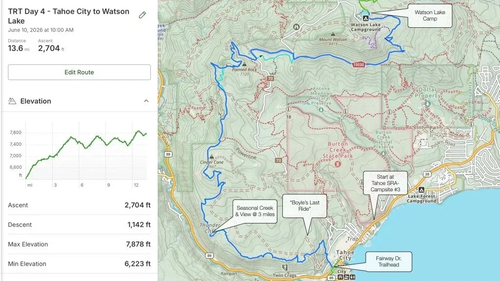
Day 4 starts at our campsite in Tahoe City where we’ll walk back to Fairway Dr., about a mile and up another .2 miles to the Fairway Community Center. The trailhead for Day 4 - Tahoe City to Watson Lake begins here and travels nearly 14 miles and ascends 2700’ before ending at Watson Lake.
The TRT book describes this section of trail, from Tahoe City to Brockway Summit, as strenuous, long with a good deal of climbing and can be quite hot in summer…and it’s mostly waterless. The book warns “This is a long stretch and water is in short supply. Year round water sources do not exist, except for Watson Lake, about 12.5 miles from Tahoe City and 6.7 miles from Brockway Summit.” It goes on to say, “ Watson Lake is shallow and its water looks unenticing to drink.”, and cautions the water should be treated. The book goes on to say, “Bring lots of water if you’re hiking this section.” You get the point…
The trail starts with a moderate climb at 6200’ and steadily climbs for about 5 miles to an elevation of about 7650’, about 1400’ of gain. The book mentions the many viewpoints of Lake Tahoe, Alpine Meadows, Palisades, Tahoe City and the Truckee River along the first section of this trail. This section of trail is also heavily travelled by MTB’s and parallels many old mining and FS roads. This section of trail has a rich history dating back to the mining ages and characters like William Boyle who was buried near the start of the trail in 1912, “so he could keep an eye on his drinking buddies.”
After the 5 mile mark, the trail heads east and goes up and down for about 8 miles before ending at Watson Lake (13.5 miles and nearly 7800’ elevation), where we are scheduled to camp for the night.
Day 5 presents some challenges like little to no water, high elevation. We can discuss if we’d like to stay at Watson Lake or push on towards Brockway Summit.
August 28, Day 5 - Watson Lake to Rose Knob Peak area
17.6 Miles, 3350’ gain
Sunrise/Sunset 6:25am - 7:36pm Temp 75/45 Partial Lunar Eclipse
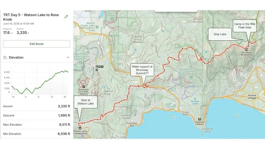
Day 5 - Scheduled to stat at Watson Lake and traverse across Brockway Summit (Hwy 267) and end at a non-designated location somewhere around Rose Knob area, hiking somewhere around 17+ miles with our largest gain so far of about 3300’.
This section of trail is relatively strenuous, starting out at about 7800’ elevation and climbs to more than 9200’. At first the trail descends from Watson Lake for about 3.5 miles, then climbs nearly 1000’ over the next 1.5 miles before descending again for another 1.5 miles into Brockway Summit (Hwy 267). At this point we are 6.5ish miles into the days hike with about 10 more steep miles to go. We should discuss a water delivery as water is severely limited.
Leaving the Highway, the trail climbs nearly 2000’ over about 7 miles to Mt. Baldy (9272’). I’ve hiked the next 3 miles of trail before the TRT splits right. The trail continues up at a slight grade, it’s exposed and has beautiful views of Lake Tahoe. Near Rose Knob Peak there are two lakes, pons really, Mud Lake on the right and Grey Lake on the left. Mud Lake is generally mud late in the year. I hiked this trail in early October and it was a mud hole. The book says Gray Lake is a pleasant and quiet place to relax with excellent campsites and is a good water source for being a shallow lake and well worth the stop. The trails leading down to the lake are said to be good trails through the tallus field, both between .6 and .9 miles, each with about 400’ of descent/gain. The book also mentions it can get very cold near Gray Lake, cold enough to create a layer of ice on the pond in August. Gray Lake is about 11.2 miles from Brockway and about 9 miles from Mt. Rose Hwy, our next stop.
Longest hike and largest gain yet.
Water likely an issue. We’ll see what Watson Lake looks like. Jess Hess to help us out at Brockway with a water delivery.
Gray Lake seems like a good place to camp.
August 29, Day 6 - Rose Knob Peak area to Mt. Rose Hwy
10 Miles, 1650’ gain
Sunrise/Sunset 6:26am - 7:34pm Temp. 76/44
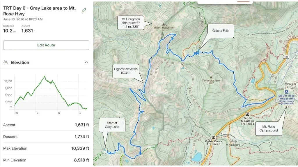
Day 6 - Starting at Gray Lake this section of trail in total is 10ish miles, a pretty short day. The challenge is our elevation starts at about 9100’ and over the first 5 miles climbs to 10,339’, the highest elevation we’ll reach on the TRT, not including potential side quests, before descending to our next camp.
After camping at or near Gray Lake the TRT climbs for nearly 4.5 to our highest elevation on the TRT to date, atop Relay Peak 10,339’ (the 6th tallest peak in the Tahoe basin). The gain is about 1200’ from Gray Lake. The air will be thin but we should be acclimated to the elevation after the previous day and camping at 9100’. The trail is described as being rocky and “exceptionally well graded” so the climb isn’t straight up. Panoramic views of the Mt. Rose Wilderness, Castle Peak, Donner Lake and the Truckee area open up to the west. Mt. Rose stands taller than Relay Peak and is seen to the east, and the Lake Tahoe views are breathtaking.
Here the trail merges with dirt roads descending steeply to a microwave radio tower. The trail merges again with a broad gravel road used by AT&T for access to the towers. Here’ we’ll have to pay close attention to the map as there are many trails criss-crossing the road. If we follow the “New TRT” correctly we meet the Mt. Rose Wilderness boundary and the out and back trail to Mt. Houghton, the 5th tallest mountain in the Tahoe Basin at 10,483’. The side quest trail is 1.2 miles out and back and about 320’ gain.
The TRT continues its descent for about 2 mile where we’ll reach Galena Falls, a reliable source of water and a good place to take in the views. At this point we are about 2.5 fairly easy miles to the Mt. Rose trailhead and our next resting spot. Across the Highway from the restrooms is the Mt. Rose Campground where we’ll try to get a First Come-First Served campsite for the night.
High altitude will challenge us. Nearly this whole section of the TRT is above 9000’.
Bag two of the highest peaks in the Tahoe Basin, #5 Mt Houghton 10,483’ and #6 Relay Peak 10, 339’.
If Gray Lake has good water we shouldn’t have to worry too much about water on this section with Galena Falls supplying us towards the end. I’ve hiked to Galena Falls in October and it was flowing pretty well.
Campsite at Mt. Rose Campgrounds could not be reserved for one night only on weekends. We’re there on a Saturday. Campsites are First-Come-First Served. Keep your fingers crossed. Site 19 for “Trail Angels”
August 30, Day 7 - Mt. Rose Hwy to Spooner Summit
24.5 Miles, 2600’ gain
Sunrise/Sunset 6:27am - 7:33pm Temp. 77/43
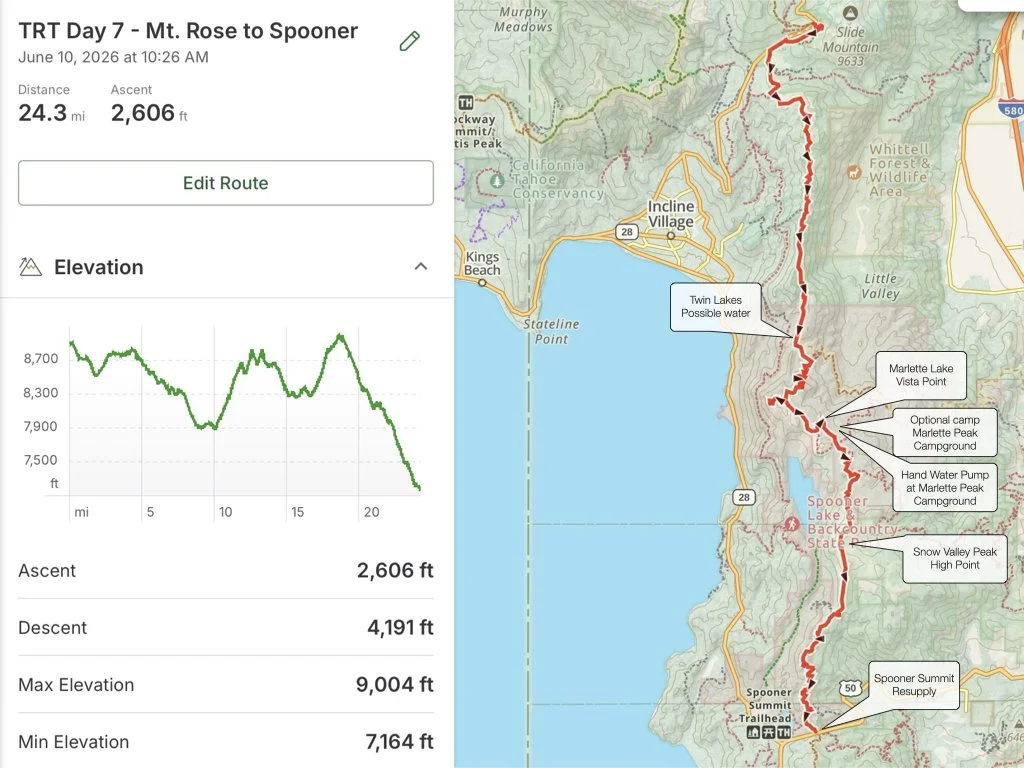
Day 7 - Mt. Rose camp to Spooner Summit, the longest section of trail at over 24 miles in one day, is the main reason this section is rated as strenuous. There’s also two decent climbs, the first at mile 10 is about 1000’ over three miles and the second is at mile 17 and is about 700’ over 2 miles before a 5 mile descent into Spooner Summit. The other challenge on this section of trail is short on water sources, a challenge we will overcome.
Starting at Mt. Rose camp (8900’) the trail descends through Tahoe Meadows to the Ophir Creek Trail. We’ll follow the Ophir Creek trail through the forest for about 1.7 miles, where the TRT and Ophir Creek Trail split. Continuing along the TRT for about 7.5 miles up and down to the Tunnel Creek Road where we have gently descended to about 8000’, which means one thing. We are now about 9.5 miles from the trailhead and meet the junction with the Flume Trail. This is also where we may get our first shot at filtered water at Twin Lakes. Twin Lakes is said to be shallow and they usually dry up by mid summer, however the best chance at water may be the higher of the two lakes. The next 1.5 miles the TRT climbs about 800’. At the top of the climb the TRT meets the Christopher Loop viewpoint on Herlan Peak, a 1.2 mile side quest that is said to be one of the best views of Lake Tahoe. This is also about the halfway point for the day.
Continuing south on the TRT another 2ish miles is another viewpoint, the Marlette Lake Vista Point and shortly after that is Marlete Peak Camp and the hand pump well, generally considered a reliable water source but it has been known to be OOS on occasion. I’ll check with TRTA before we leave to confirm its status. After a short hike begins the second climb, nearly 3 mile 700’ climb to the saddle below Snow Valley Peak, the highest point on this section of trail sitting at 9196’ at the peak. Now begins the 5 mile descent to Spooner Summit.
Tiff will meet us at the Summit and take us to Zephyr Cove Campground where we’ll restock and spend the night
Longest section of the TRT for us, about 24.5 miles.
Little water on this section of trail. Possible sources at Twin Lakes and the Marlette Peak hand pump. Hess’s stash at TRT x Tunnel Creek Rd.
Amazing Lake views most of the trail with a couple side quests that might be worth the views.
Tiff to pick us up at Spooner Summit. Restock and drive us to camp.
Camp at Zephyr Cove Campground, Loop 2, site 5 #080613882.
August 31, Day 8 - Spooner Summit to Kingsbury North
12 Miles, 2200’ gain
Sunrise/Sunset 6:28am - 7:31pm Temp
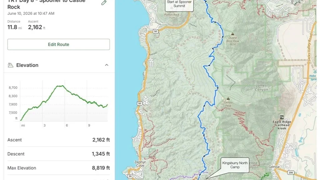
Day 8 - Spooner to Kingsbury North, after a long 24 mile day, a good nights sleep and a restock, the early morning start should get us to the finish of a 12 mile day early. Rated as moderate, this section starts with a steady climb of about 1600’ in 5 miles then flattens out before descending into Kingsbury North Trailhead, our camp for the night. The biggest challenge will be the lack of water on this section of trail. Water is not available between Spooner Summit and Kingsbury North.
The mostly sandy trail climbs moderately up a somewhat open slope. The trail is exposed and the sun can be relentless. This area was logged and signs of the logging operation remain. The payoff…great views of South Lake Tahoe across to Desolation Wilderness and Emerald Bay to the west. This section of trail is also a popular mountain biking trail so be heads up for bikers. The open terrain also is a popular area for deer, bear and even mountain lion, BOLO.
An increasingly steeper climb continues to the top of South Camp Peak (8800’), through a much more forested area. South Camp Peak is a large, level area, a great spot to take a break and continue enjoying the unobstructed views of SLT, Heavenly, Desolation/Tallac area, the west shore around to Tahoe City area to the north. This is about the 5 mile mark.
A 5ish mile descent begins at South Camp Peak through a forested area and eventually meets the junction of the TRT and Kingsbury Grade North access trail. A mile hike to the left brings us to the Kingsbury North Trailhead with restrooms and water. A mile hike to the right brings us to Castle Rock (aka Jasons Rock) a great viewpoint of SLT and a place made famous in our memories by J. Black. The official TRT heads towards Castle Rock and also will loop around to the Kingsbury North Trailhead. Somewhere in this location may be a good place to camp.
A fairly short day with a decent 5 mile climb.
No water on this section of trail
Kingsbury North Trailhead, the end of the section, has restrooms and water.
This area is a good place to camp. Also, another 5 miles past this location is a campsite near the annual Edgewood Creek that may also work.
September 1, Day 9 - Kingsbury North to Star Lake
15.2 Miles, 3000’ gain
Sunrise/Sunset 6:29am - 7:29pm Temp
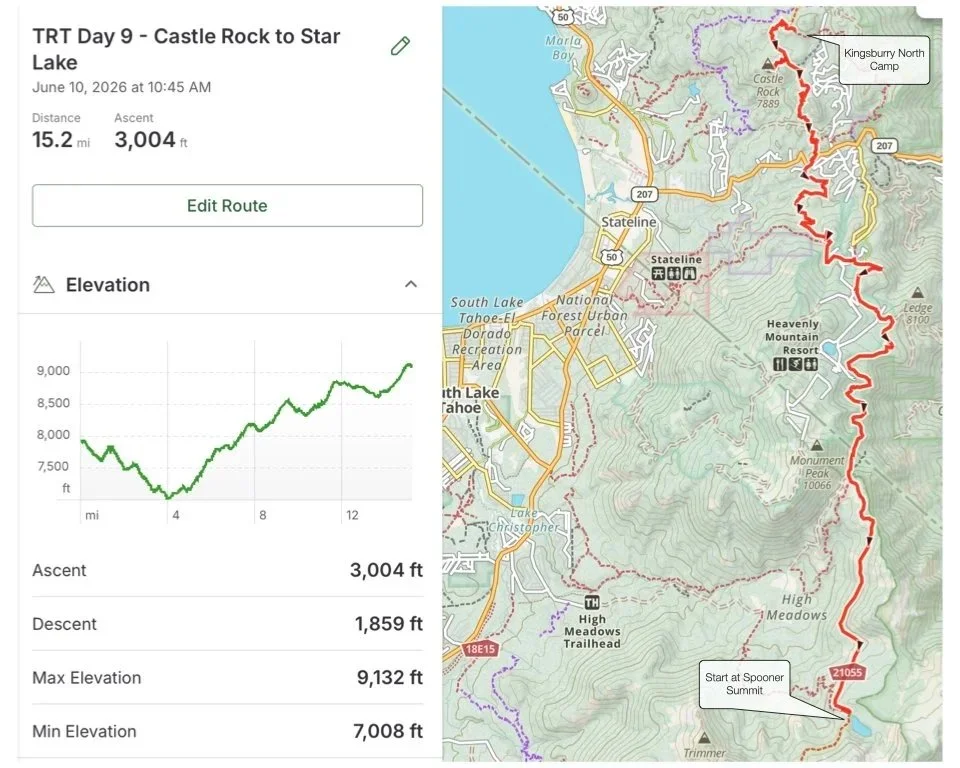
Day 9 - Kingsbury North to Star Lake - A 15 mile day with a challenging climb from 7000’ to about 9100’, across Kingsbury Grade, across Heavenly to Star Lake. This section has big views, is popular with hikers and bikers and ends at Star Lake (8.8 miles from Kingsbury Grade South Trailhead). This section of trail is said to be exposed to the sun and sunscreen is recommended. Unlike much of the east shore, there seems to be a decent amount of springs and creeks along this section of trail, however some are seasonal and may run dry.
If we choose to start from Kingsbury North Trailhead, the trail descends from about 8000’ to about 7000’ in 3ish miles to Kingsbury Grade. This is where the climb begins. Over the next 11 miles or so we will climb to about 9100’. We have an option to discuss. We may elect to continue past Kingsbury North about 5 miles to Edgewood Creek, a reliable water source with a campsites nearby. This won’t do much for our climb but we will be closer to Star Lake. Curious your thoughts.
Continuing from Edgewood Creek we’ll climb as we pass through Heavenly, across ski runs and under chairlifts, across a few roads and through some granite terrain and forested slopes. There is also popular mountain bike terrain along some of these slopes. About 5 miles from Kingsbury Grade we’ll pass one of the largest western white pines in the Tahoe region. Designated this by the US Forest Service, the pine has a circumference of 24’.
The trail climbs to about 8800’ to Monument Pass, about 8ish miles from Kingsbury Grade and nearly 3 miles to our destination at Star Lake. As the TRT climbs along these slopes, it is overshadowed by the tallest peaks in the Tahoe basin, Freels Peak, Job’s Peak and Job’s Sister, all standing above 10’600’.
Shortly, Star Lake appears just in time for a dip in its cold waters. This is the only large lake on the TRT between Mt. Rose and Luther Pass and also our camp for the night. Star Lake may seem like a great place to filter water however the book says it’s high silt content may clog filters, just an fyi. A better water source is recommended about a mile past Star Lake at Cold Creek. We end our day at Star Lake.
Decision point - Stay at Kingsbury North or continue 5 miles to Edgewood Creek? This will lengthen a short day (Day 8 from 12 to 17 miles and shorten a long day, Day 9).
Another significant climb from about 7000’ elevation to 9100’ with about 3000’ of climb over about 11 miles.
The water situation improves along this section of trail with water at Kingsbury North Trailhead, Edgewood Creek, Star Lake and a few seasonal streams in between.
September 2, Day 10 - Star Lake to Luther Pass
14.1 Miles, 1550’ gain
Sunrise/Sunset 6:29am - 7:28pm Temp
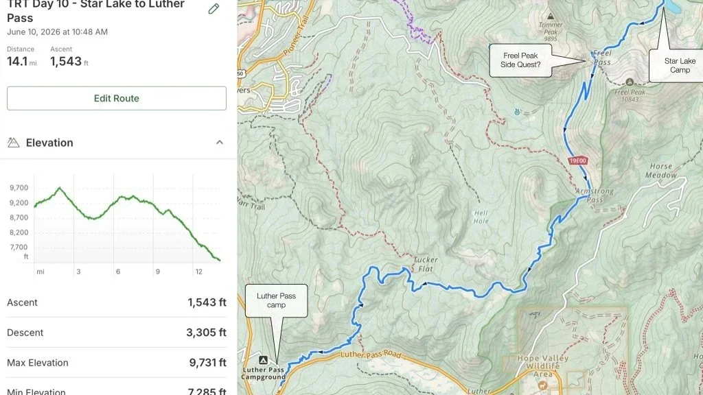
Day 10 - Star Lake to Luther Pass Camp, characterized by a moderate climb out of Star Lake (9100’) to Freel Pass, (9700’) then comes a decision, conquer the Freel Peak side quest (2 mile out and back, 1200’ gain) or continue along the TRT. With 12 miles to hike before the next stop. What will we choose? The TRT descends from Freel Pass to Armstrong Pass before ascending again about 700’ over about 2.5 miles. It’s all downhill from there, about 6.5 miles to Luther Pass camp.
Starting at Star Lake a moderate climb begins and continues for the next 2 miles to Freel Pass. We will pass a good water source about a mile from Star Lake. Cold Creek is said to be small but “bustling with happy energy.” It’s a good place to grab water. Next we arrive at Freel Pass. Here we’ll make a decision to hike to Freel Peak, the tallest peak in the Tahoe Basin at 10,843’. The trail to Freel Peak is about a mile and gains almost 1200’ through a series of switchbacks and a “worker” of a climb. The views from the top are pretty incredible! Jason and I hiked it in October of 2020. Once at the top you have another decision to hike to nearby Jobs Sister (10,823’, about another mile) and then return to Freel Pass to continue on through TRT.
Continuing downhill about another 3 miles we arrive at Armstrong Pass. The views along this section of trail are pretty great! Continuing straight on the TRT we’ll begin an ascent of nearly 3 miles and 700’ of gain. This section of the TRT is also a popular mountain Bike section. Many trails lead into SLT from this location. Soon the TRT will traverse Freel Meadow. Traverse the meadows (3 of them) the TRT reaches the Saxon Creek Trail aka Mr. Toad’s Wild Ride. 4.5 miles further the TRT arrives at the Luther Pass Campground where we’ll meet Tiff for or last resupply before she heads out of town. There is a restroom and water at this location as well. Our final section of the TRT awaits starting across the highway at the Big Meadow Trailhead.
Grab water at Star Lake or nearby Cold Creek.
Side quest to Freel Peak??
Meet Tiff at Luther Pass camp for resupply/offload before she heads home and before our last day on the TRT.
Luther Pass camp is First Come-First served. No reservations here.
September 3, Day 11 - Luther Pass to Echo Lakes
17.6 Miles, 3000’ gain
Sunrise/Sunset 6:30am - 7:26pm. Temp
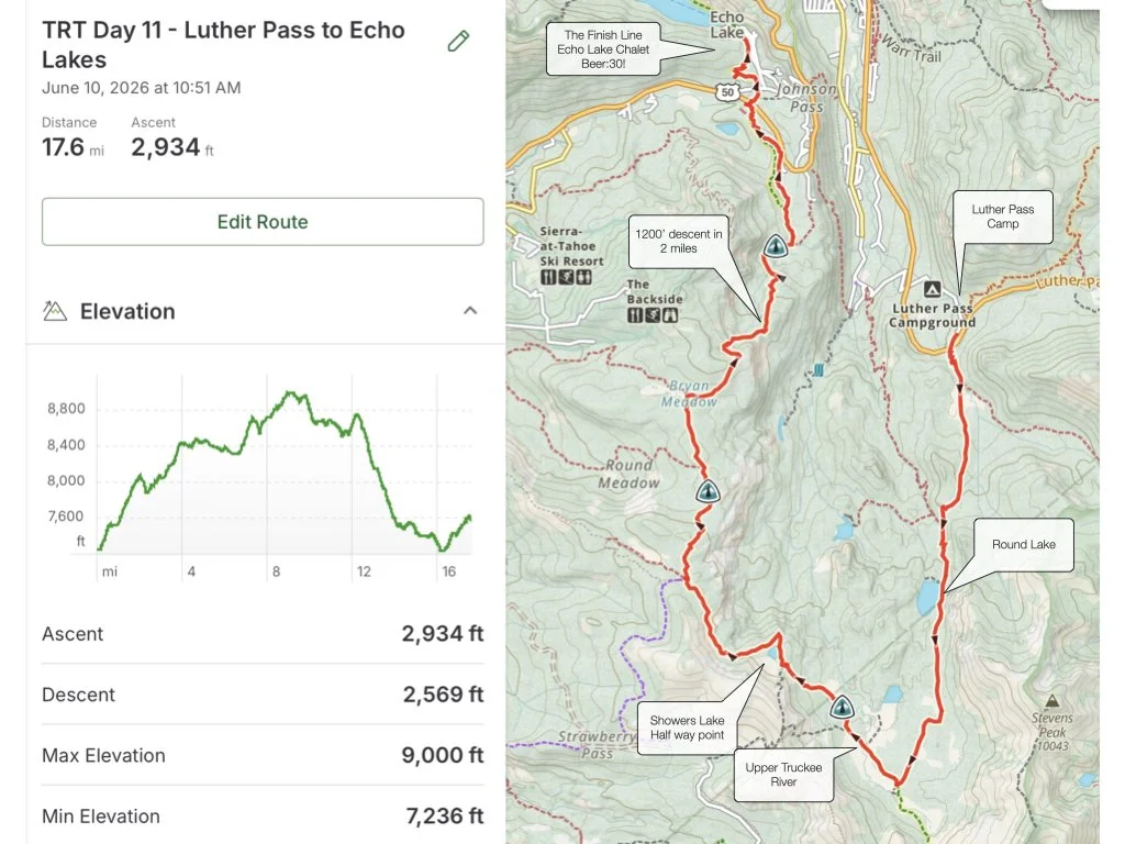
Day 11 - Luther Pass to Echo Lakes…the finish line! Our last day on trail is characterized as a moderately strenuous section of the TRT. Most of the trail is gentle up and down terrain through meadows and open fields. There are several sustained climbs that are not too steep. The most difficult part of this section is between Bryan Meadow and Benwood Meadow, about 12 miles from Big Meadow Trailhead where the trail descends about 1500’ in 4 miles.
This section of trail has several good water sources and if we finish early we can enjoy something more than water at the Echo Lakes Chalet.
The trail starts at its lowest point at Big Meadow Trailhead and moderately ascends over about .3 miles to Big Meadow where the trail flattens out and big views can be had. The TRT continues up and down for about 2 miles where you reach the junction to Dardanelles Lake, a 1.4 mile side quest. Another .6 miles on the TRT the trail reaches the NE corner of Round Lake, the largest lake on this section of trail offering great swimming and camping. Hiking past Round Lake the trail is mostly a level walk through wildflowers and aspens.
Nearly 5 miles from the trailhead the TRT merges with the PCT. This is also the southernmost point on the TRT. Turn right at this junction and head north towards the Upper Truckee River, a good place to grab more water if we need it. A fairly steep .5 mile climb is next, just before Showers Lake. The north side of Showers Lake provides great swimming and water access. Its also a good campsite if one is needed, but it is also one of the most popular places to camp on the TRT.
Continuing north about 4.4 miles from Showers Lake the trail reaches Bryan Meadow. This is about 4 miles from Echo Summit. A .5 mile steep climb the trail levels out for a bit, then the “bone-jarring, toe-jamming, Knee-breaking” 2 mile downhill begins. The TRTA has improved the trail with switchbacks to ease the descent but it is still very steep. The trail eases as it reaches Benwood Meadow, a good place to give the knees, ankles and feet a rest before continuing.
In 2.2 miles the TRT/PCT crosses Hwy 50 and about another 1.5 miles we cross the finish line. I hope I still have the keys to my truck! If we arrive in time we can celebrate with an ice cold “soda” from the Echo Lake Chalet before heading to Jakes Cabin on the north side of the lake…Job Well Done!
The last day!
Plenty of water along the trail and a mile section of trail as far as significant gain goes. More-so the 2 mile descent sounds like it can be really tough.
Finish back at Echo Lakes and drive to Jakes place on the north side.
TRT complete!!
